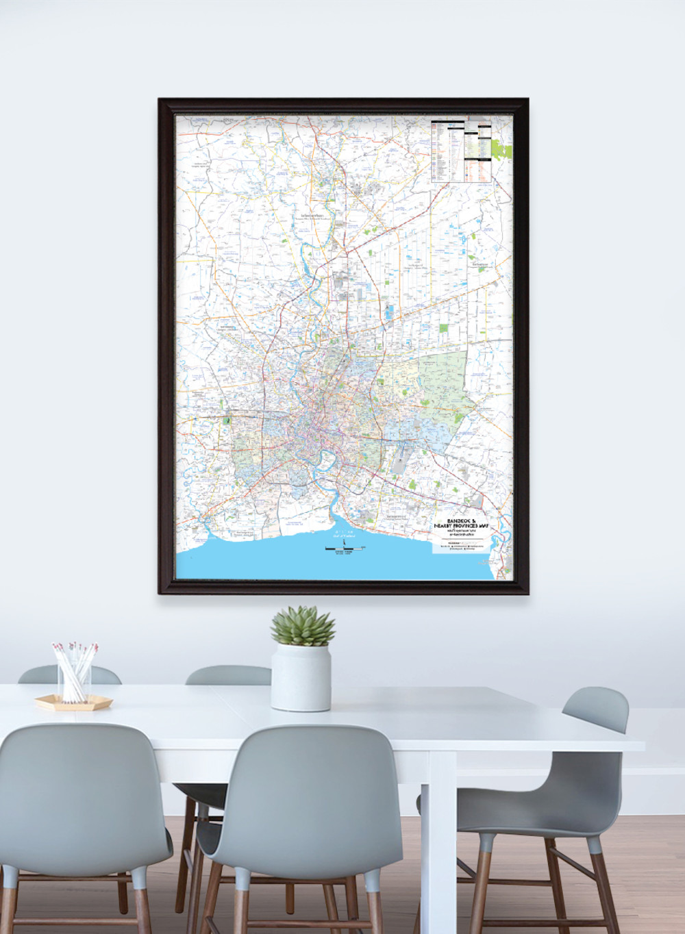
Map of Bangkok and Nearby Provinces
฿449 - 8,999
Media :

Sheet

Roll-up

Frame

Frameless

Board
Quantity :
Product Details
The map covers the overview of Bangkok and neighboring provinces.
• Bilingual: Thai-English.
• 2022 updated.
• Shows 50 administrative divisions of Bangkok, divided by colors: Phra Nakhon, Dusit, Nong Chok, Bang Rak, Bang Khen, Bang Kapi, Pathum Wan, Pom Prap Sattru Phai, Phra Khanong, Min Buri, Lat Krabang, Yan Nawa, Samphanthawong, Phaya Thai, Thon Buri, Bangkok Yai, Huai Khwang, Khlong San, Taling Chan, Bangkok Noi, Bang Khun Thian, Phasi Charoen, Nong Khaem, Rat Burana, Bang Phlat, Din Daeng, Bueng Kum, Sathon, Bang Sue, Chatuchak, Bang Kho Laem, Prawet, Khlong Toei, Suan Luang, Chom Thong, Don Mueang, Ratchathewi, Lat Phrao, Vadhana, Bang Khae, Lak Si, Sai Mai, Khan Na Yao, Saphan Sung, Wang Thonglang, Khlong Sam Wa, Bang Na, Thawi Watthana, Thung Khru, and Bang Bon.
• Shows amphoe (district) boundaries of 10 neighboring provinces, which are Nonthaburi, consisting of 6 amphoe, Mueang Nonthaburi, Pak Kret, Bang Kruai, Bang Yai, Bang Bua Thong, and Sai Noi; Samut Prakan, consisting of 6 amphoe, Mueang Samut Prakan, Bang Bo, Bang Phli, Phra Pradaeng, Phra Samut Chedi, and Bang Sao Thong; Pathum Thani, consisting of 7 amphoe, Mueang Pathum Thani, Sam Khok, Lat Lum Kaeo, Khlong Luang, Lam Luk Ka, Thanyaburi, and Nong Suea; some parts of Phra Nakhon Si Ayutthaya, consisting of Amphoe Phra Nakhon Si Ayutthaya, Bang Sai, Bang Sai, Bang Ban, Bang Pa-in, Phak Hai, Phachi, Lat Bua Luang, Wang Noi, Sena, Uthai, and parts of Tha Ruea, Nakhon Luang, and Bang Pahan; Samut Sakhon, consisting of Krathum Baen and some parts of Mueang Samut Sakhon; Chachoengsao, consisting of some parts of Mueang Chachoengsao, Ban Pho, and Bang Nam Priao; Nakhon Pathom, consisting of Phutthamonthon and some parts of Nakhon Chai Si, Sam Phran, and Bang Len; Suphan Buri, consisting of some parts of Bang Pla Ma; Saraburi, consisting of some parts of Mueang Saraburi, Nong Khae, Nong Saeng, and Wihan Daeng; and Nakhon Nayok, consisting of some parts of Ongkharak and Ban Na.
• Shows major highways, main roads, minor roads, shortcuts, and soi (alleys).
• Shows important spots such as business districts, airports, government offices, district offices, and tourist attractions.
• Shows index of distance information, significant spots, etc.
• Shows spots of railway stations, bus terminals, ports, police stations, hospitals, schools, shopping centers, markets, wat (temples), rivers, canals, etc.
• Shows routes and mass rapid transit projects; BTS Sukhumvit Line, BTS Silom Line, BTS Gold Line, Airpot Rail Link Line, Chaloem Ratchamongkhon Line, Chalong Ratchadham Line, MRT Orang Line Project, MRT Yellow Line Project, MRT Pink Line Project, Green Line Extension Project, and SRT Red Line Commuter Project.
• Latest and upcoming main roads updated.
• Size (XL) 100x138 cm has a scale of 1:90,000, Size (L) 83x120 cm has a scale of 1:100,000, Size (M) 69x100 cm has a scale of 1:120,000.
• Detailed map, suitable for business management.
• Size (XL) 100x138 cm is recommended for better map details.


